


Winter hiking in Austria: discover the most beautiful routes in Vorarlberg
- Oscar & Marjolein

- Dec 27, 2024
- 8 min read
Winter sports are so much more than just skiing or snowboarding. For those who don't want to hit the slopes every day - or even ski at all - winter hiking is a perfect way to enjoy the mountains. We were in Vorarlberg at the end of December. This is one of those destinations where you can enjoy hiking to the fullest. In this blog, we share our experience of some of the most beautiful winter hiking routes in Vorarlberg.
What should you take with you on a winter walking holiday?
Good preparation is important for a successful winter walking holiday. Here is a checklist of what you should definitely take with you:
Thermal clothing: well-insulated undergarments ensure that your body stays at the right temperature.
Windproof and waterproof jacket: protects you from the cold winter wind and is great when it snows.
Thick walking trousers or ski trousers: when wearing walking trousers, we recommend wearing well-insulated thermal trousers underneath. Ski trousers have the advantage of also being windproof and waterproof.
Waterproof walking boots or snow boots: the snow on the paths is well trodden and flattened. As soon as you step off the path, you may find yourself knee-deep in snow. Higher shoes or boots are therefore recommended.
Walking sticks: for that little bit of extra grip or support.
Hiking rucksack: always handy for food and drink on the go. And in our case, for the camera.
Hat, scarf and gloves: once the sun is shining, you won't need them so much. But as soon as the sun goes away, it gets cold quickly.
Sunglasses: sun + snow = white, white and more white.
Blister plasters: when walking in the snow, there is a chance of wet socks. This creates more friction and increases the risk of blisters.
Crampons (optional): especially useful when walking on less well-maintained paths.
Layering is also very important when winter hiking. As soon as the sun starts shining on the mountain, it can quickly become warm. There is a good chance that you will need fewer layers along the way than you started with.
Best time for winter hiking in Vorarlberg
The best time for winter hiking in Vorarlberg is between late December and February. During these months, almost all ski resorts are open, and the chances of good snow conditions are high. In general, the higher up in the mountains, the greater the chance of thick snow cover.
The winter hiking trails in Vorarlberg are well maintained and clearly marked with pink signs. This makes it easy to follow the routes, even if you are less familiar with the area. For a complete overview of all winter hiking routes, visit the official Vorarlberg tourist website.


Where to stay in Vorarlberg?
We stayed at Business Hotel Maier in Götzis, a comfortable base for hiking in Vorarlberg. The hotel has spacious rooms with your own kitchen, bathroom and sitting area. It is centrally located and offers quick access to various starting points for beautiful routes. There are also plenty of great places to eat, with lovely restaurants in the centre, such as:
Day 1: Furkla-Höhenwanderweg hike – Bürserberg
Distance: 10.8 kilometres
190 metres ascent | 590 metres descent
Lowest point: 1,175 metres | Highest point: 1,746 metres
GPX route:
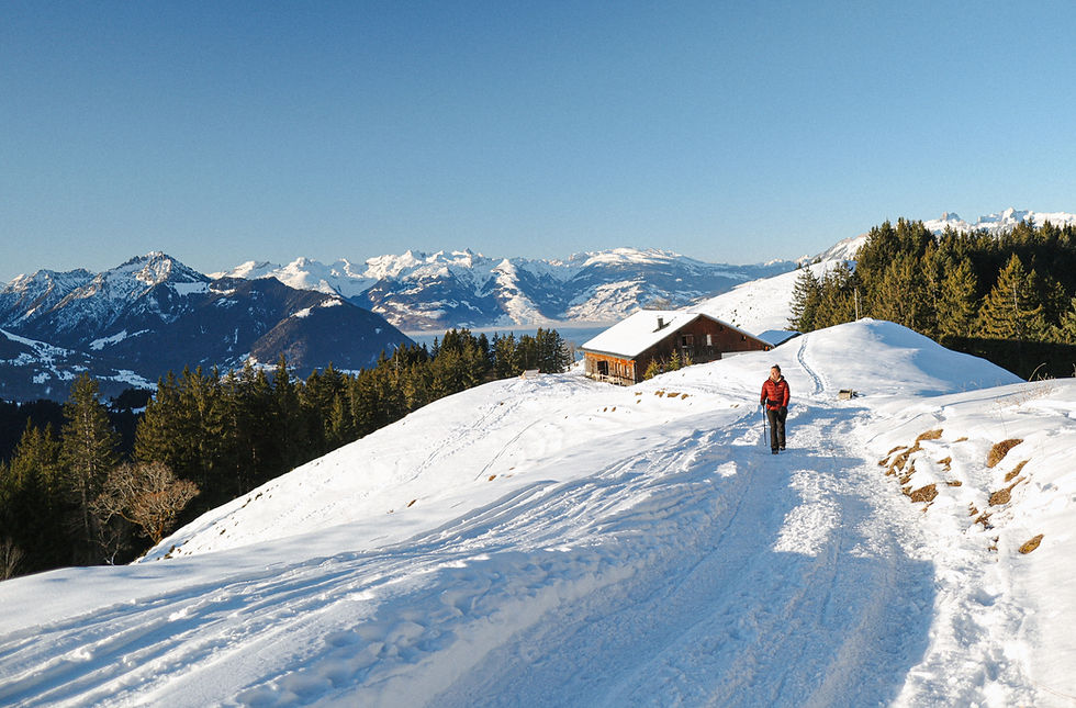
Our day began in the winter sports village of Brand. After searching for a parking spot for a while, we parked our car near the Dorfbahn ski lift. To get to the starting point of the Furkla Höhenwanderweg, you first take this ski lift and then the Panoramabahn. After about 20-30 minutes, we arrived at the top, where we were immediately treated to a beautiful contrast: down in the valley it was cold and foggy (-4 degrees), but up on the mountain the sun was shining brightly under a clear blue sky. It almost felt warm – what a difference!


Please note! Both lifts offer a special day ticket for hikers, which is a cheaper alternative to a ski pass. On the advice of an employee, we bought a single ticket for the ascent. The Furkla Höhenwanderweg is normally a 10 km round trip, but we followed a different path down from the end. For the last part, we took the “Einhornbahn” ski lift from Tschengla to Bürserberg for free, after which the bus took us back to the car park for free. If you follow the entire Furkla Höhenwanderweg, buy a return day ticket to use the same lifts on the way back.
The Furkla Höhenwanderweg is a well-maintained winter hiking trail. The pink markings, typical of the winter hiking trails in Vorarlberg, make it easy to find your way. From the starting point, we walked slightly uphill to the Parpfienzsattel. After this, the path descended slightly and we continued along the ridge towards the Furkla Alpe.
The route is beautiful: glistening snow, snow-covered pine trees and panoramic views. You look out over the Rätikon mountains, including the “Zimba” peak. This is also known as the smaller version of the Matterhorn, at 2,643 metres high.


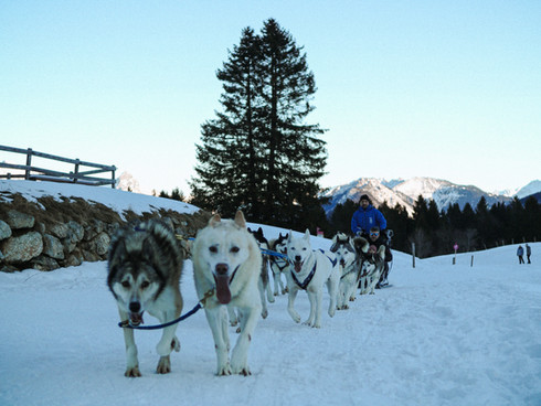
The advice to take an alternative route back turned out to be a great tip: the last part of the walk offered even more beautiful views, especially with the setting sun turning the sky pink and orange. Before you reach the ski lift, you walk through the village of Tschengla. Here we were passed by a pack of huskies pulling a sledge. You can book a tour like this from the village. We arrived at our car just before dark – perfect timing after a fantastic first day of snow hiking!


Day 2: Hike from Kalbelesee to Körbersee
Distance: 5.81 kilometres
190 metres ascent | 190 metres descent
Lowest point: 1,654 metres | Highest point: 1,746 metres
GPX route:
On the second day, we walked from Kalbelesee to Körbersee, a 6-kilometre round trip. We deliberately chose a shorter hike because we had planned to visit the sauna in the afternoon.
The walk starts at the Hochtannberg Pass. Although the drive from our flat in Götzis would normally take just over an hour, it took us more than two hours due to traffic congestion near the Damüls-Mellau ski area. Fortunately, we were able to enjoy the beautiful scenery along the way, which made the wait a little more bearable. On the way, we drove along the Bregenzerwaldstraße. Around the village of Schröcken, the road curves over an elevation on stilts with a beautiful view in the background, making it a great spot for photos. Once we arrived, we managed to get one of the last parking spaces.


The route for this day was very different from the previous day: more open terrain and sweeping views, with lovely sunshine again. We started at an altitude of 1,654 metres and first climbed the mountain, then descended to Lake Körbersee. The route mostly follows winding ski slopes, and in some places you also cross the slopes. This means that, in addition to the beautiful views, of course, there is plenty to see along the way. The lake was frozen and covered with snow, which made it feel a bit cooler in the shade.
For lunch, we found a spot in the sun with a view of the slopes. It was lovely to sit there and watch the skiers and snowboarders. A short but beautiful walk, ideal to combine with a relaxing afternoon!


Wellness visit at Hotel Warther Hof
From the car park at the start of the walk, it was only a few minutes' drive to the Wellnesshotel Warther Hof. Here we bought a day pass for €95 per person. This pass gave us access to the saunas, swimming pools and a buffet lunch with unlimited (non-alcoholic) drinks. We also received a bathrobe, bath towel and slippers. We arrived around 1 p.m. and had the entire resort almost to ourselves. It only starts to get busy here around 4 p.m., when people come off the slopes.
The saunas were wonderfully relaxing, and what made it extra special was the view of the mountains. Swimming in the heated outdoor pool with such a view is also delightful. This wellness experience, combined with the surrounding nature, was a wonderful end to an active and relaxing day.


Day 3: Hike from Latschau to the Lindauer Hütte through the Gauertal valley and downhill by sledge
Distance: 14 kilometres
726 metres ascent | 726 metres descent
Lowest point: 1005 metres | Highest point: 1735 metres
GPX route:
Our third hike in Montafon was quite a climb this time: from 1,017 to 1,744 metres in about three hours. The hike starts in the village of Latschau and leads via a short, steep climb to the Rasafeibrücke. Here you can choose between two routes to the Lindauer Hütte. We went right so that we could take the toboggan run on the way back. Along the way, we walked through the Gauen district, a fairytale snow-covered forest, and ended with a beautiful climb with a view of the imposing Drei Türme.


We stopped at the Lindauer Hütte for a well-deserved lunch of Kaiserschmarrn. Then the real adventure began: sledding downhill. You can rent a sledge at the hut for €10. Every so often, the sledges are brought back up, so sometimes you have to wait a while. You leave the sledge behind at the bottom.


The first part took some getting used to – you steer with your feet (left in the snow to turn left, right to turn right), while holding the back of the sledge with one hand. The more you lean back, the faster you go. The 7-kilometre descent through the Gauertal valley was fantastic. The route was steep, with bumps here and there, but we quickly mastered the technique and were able to enjoy ourselves to the full. We do recommend getting down before dark, though. After the sun went down, the top layer of snow froze, making it more difficult to brake and creating dangerous situations.


Day 4: Hike from Dafins to Alpwegkopf
Distance: 11.7 kilometres
575 metres ascent | 575 metres descent
Lowest point: 922 metres | Highest point: 1482 metres
GPX route:
Our last morning in Vorarlberg started early: we got up to see the sunrise from Alpwegkopf. The walk starts above the village of Dafins (794 metres). From the ‘car park’, you follow a mountain road to Madlensalpe. We started walking at 7 a.m., when it was still dark. Fortunately, the glistening snow provided some natural light.
The first part of the route was along a tractor path, but we soon entered the forest. As it grew lighter, the sky turned beautiful colours. The route uphill was challenging: a 700-metre climb on a path that was less well maintained than we were used to. Some sections were icy, others covered in deep snow, which made the climb difficult. Crampons and walking sticks can be useful on this route.


When we finally reached the tree line, we saw that the sun was just behind the mountain peaks. We reached the Alpwegkopfhaus, and with it the summit, around 9 o'clock. From there, we walked a little further to the viewpoint. We were just in time for sunrise. All alone, we enjoyed the moment when the sun warmed the surroundings and coloured everything in golden hues. From the summit/ridge, you have panoramic views of the Rhine Valley and the surrounding mountains, such as the Schesaplana and the Churfirsten.


For the return journey, follow the same route as on the way up, with magnificent views of the Rhine Valley and the Hohe Freschen. The descent was considerably faster. Along the way, we encountered more and more hikers who were now beginning their climb. With a few extra photo stops along the way, we were back at the car by the end of the morning.


In conclusion
Our winter walks in Vorarlberg were a perfect mix of activity and relaxation. Whether you are an experienced hiker or simply looking for an alternative to skiing, Vorarlberg offers something special for everyone. We hope our blog inspires you to discover this beautiful region in winter too.


Comments