


Peaks of the Balkans: A complete guide to the Balkan Trail
- Oscar & Marjolein

- May 14, 2024
- 15 min read
The Peaks of the Balkan trail is a 192-kilometre hiking route in the border region of Albania, Montenegro and Kosovo. It is a relatively new trail with a collection of beautiful mountains shared by the three countries. The route itself is challenging and requires good physical condition, but offers one of the most authentic and unspoilt nature experiences in Europe. From hospitable shepherd villages to panoramic views, it is a journey for the true adventurer.

What do you need to know before you go?
Border crossings and permits: You will need special permits to cross the borders between Albania, Montenegro and Kosovo, as there are no official border posts along the trail. However, local authorities may ask for a permit when you cross the border. It is best to arrange these permits through a local organisation so that they are stamped and approved by the relevant authorities. We arranged our permits through Balkan Mountain Adventure Company for €50 per person. This allows you to follow the entire route without any problems and you don't have to worry about a possible fine along the way. Start applying for the permits in good time, as it may take a while before you receive them (by email).
Local calls and internet: Upon arrival at Tirana airport, it is useful to purchase a local SIM card. Because the Peaks of the Balkan trail is located in a remote area, it is nice to have access to the internet and to be able to make local calls. Provided there is coverage, of course. We purchased a Vodafone SIM card with 15 GB and a few call minutes for 1500 Lekë (approximately €15).
Currency and payment options: Although the official currency in Albania is the Lekë, you can also pay with euros in many places, which makes carrying large amounts of Lekë unnecessary. Withdrawing Lekë in Albania itself cost us quite a bit of money due to the transaction fees charged by the ATMs. In hindsight, this was unnecessary. In Kosovo and Montenegro, the euro is the common currency, so you don't need to carry multiple types of money with you. Keep in mind that there are few to no ATMs along the trail.
Transport from the airport: In Albania, we use the UP's Taxi app. This is similar to Uber and a cheaper alternative to standard taxis. You can see the price you will pay and how long it will take for the taxi to arrive in advance. For comparison: a normal taxi ride to our hotel costs €25, but with UP's taxi it cost €16. A credit card is required to use the app.
When is the best time to walk the Peaks of the Balkan trail?
The best time to explore the Peaks of the Balkan trail is from June to October. During this period, weather conditions are favourable, the snow has mostly melted on the higher trails, and the accommodations along the trail are open. For hikers who want to take advantage of the quieter trails and beautiful autumn colours, September or early October is recommended.
In spring, until early June, there is often still a lot of snow in the mountains, which can make certain trails difficult or even impassable. We went at the end of May and found that we needed extra equipment and caution on some sections due to the snowy patches. If you do go in spring, keep in mind that not all guesthouses are open. We recommend booking in advance and giving them a call to make sure you have a place to stay.
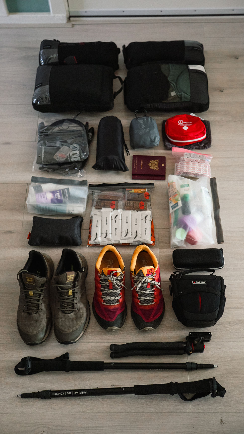
What should you bring on the Peaks of the Balkan trail?
Good preparation is essential for a successful and safe trek through the mountains. Click on the link below for the complete packing list of items we took with us.
We highlight the most important items below:
Brace: To support your knees and ankles. Oscar sprained his ankle on one of the first days. Thanks to the brace, he had enough support to keep walking in the days that followed.
Water purification tablets or disinfectant: Although most guesthouses claim that the water is drinkable, we do not recommend it. We have heard several stories of people who have become ill from drinking the water. Especially in summer, it is risky to drink water directly from the tap, as it sometimes comes from the stream where livestock also drink. We brought a bottle of Hadex drinking water disinfectant with us. Every morning, we filled our hydrobags with water and then added a few drops from this bottle. The only downside is that the water takes on a slight chlorine taste. But we didn't get sick.
Energy tablets and date bars: Most guesthouses will provide a “picnic” upon request. This is a packed lunch for the journey. For extra energy, we bought energy tablets and date bars in advance at Decathlon. You dissolve the energy tablets in your hydration pack or water bottle. This also gets rid of the chlorine taste of the Hadex.
White sports tape: In our opinion, a real must-have. Blister plasters are always handy to have with you, but they didn't stay in place very well during a long day of walking. With an extra layer of sports tape around them, everything stayed in place. Also useful for support in case of injuries and emergency repairs along the way.
Organiser bags: This last tip ensures that your belongings remain well organised in your backpack. We purchased our organiser bags via AliExpress, and they ensured that we had everything quickly to hand.
Day 1: Travel day from Tirana to Valbonë via Lake Komani
To travel from Tirana to Valbonë, we recommend travelling via Lake Komani. We arranged the entire trip through Berisha. They arrange a pick-up with a taxi bus from Tirana to Koman. From Koman, you then take the iconic Komani Lake Ferry, which takes you through beautiful gorges. After the boat trip, it is another taxi bus ride to Valbonë, where the Peaks of the Balkan Trail begins.
Valbonë, a quiet mountain village, is the starting point for many hikers on the Peaks of the Balkan Trail, a circular route that eventually brings you back to your starting point. Below is the itinerary for this first day:
5:30 a.m.: Pick-up at Gazheli Petrol in Tirana. This is the designated meeting point for everyone. The taxi ride to Koman takes 3 hours and costs €12 (1400 Lekë). The first 1.5 hours were fine, but then the bumpy ride began. A bumpy mountain road with lots of bends. We were glad when we arrived at the boat.
8:30 a.m.: Departure by ferry from Koman to Fierze. The boat trip across the lake offers spectacular views of high cliffs and crystal clear water and gives you a taste of the rugged mountain landscape that awaits you. Unfortunately, there is a lot of rubbish in the water... The crossing takes 3 hours and costs €8.80 if you book online or €10 cash (1000 Lekë) on the spot.


12 noon: Pick-up from Fierze to Valbonë. This last journey takes 1 hour and costs €8 (800 Lekë). The driver will ask where you are staying in Valbonë and drop you off as close as possible.
1:00 p.m.: Arrival in Valbonë. We spend the night at the Montain Rosi guesthouse. It's a 40-minute walk from the centre of Valbonë, which makes it a bit less appealing... But the advantage is that you're higher up in the mountains, so you have a beautiful view. In addition, the owners are incredibly nice (you will read this about more people in our blog) and we were served delicious homemade traditional dishes. One dish that stuck with us is called “Flija”. It is a cake consisting of crêpe-like layers covered with cream. Very soft and tasty.


Day 2: Valbonë to Çerem via the Preslopi Pass
Distance: 21 kilometres (15.8 kilometres official route)
1,159 metres ascent | 1,069 metres descent
GPX route:
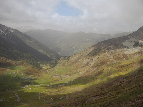
To get from Valbonë to Çerem, you have two options: via a paved road or via the Preslopi Pass. If conditions are good (no rain or snow), we definitely recommend taking the Preslopi Pass. It offers a very diverse landscape: rugged rocks, forests and flower-filled valleys. During our trip at the end of May, there was still snow in a number of places. Normally, there is much more snow at this time of year. Fortunately, our walking sticks provided some grip, but the snow was slippery and sometimes covered the footpaths, forcing us to find another route. This sometimes led to some tense situations.


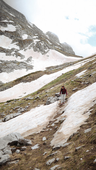


In addition to the snow, the route itself is also challenging: climbing 1,169 metres and descending almost the same distance is no mean feat. Especially when you are constantly walking on rocks. So it was a tough first day, but above all incredibly beautiful. We thoroughly enjoyed ourselves.


One of the special features along this route is a cave where the temperature is always 0 degrees, whether it is summer or winter. From this cave, you have a beautiful view of Zla Kolata, the highest mountain in Montenegro. Unfortunately, at this time of year, there was still too much snow to climb to the top of this mountain in normal hiking gear, but otherwise it seems to be possible with a small detour.


We hadn't booked a guesthouse for the night. We arrived as it was getting dark, but luckily we saw lights on at one of the guesthouses. After knocking several times, we were warmly welcomed by the owner of Guesthouse VITA. Fortunately, we were able to join them for dinner right away. Just before bedtime, we were served rosemary tea. This herb grows everywhere here and we enjoyed its scent all day long.
Day 3: Çerem to Döberdol
Distance: 18.3 kilometres (15.5 kilometres official route)
1,053 metres ascent | 466 metres descent
GPX route:
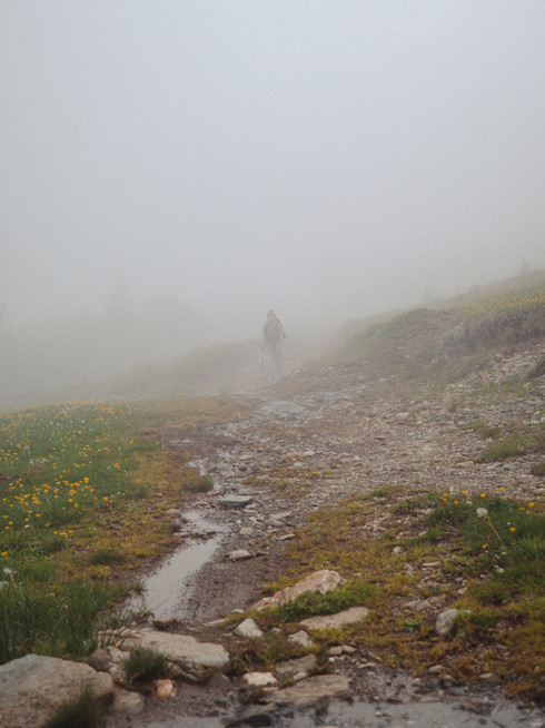
When we woke up this morning, the entire village of Çerem was shrouded in fog. Hoping that the weather would clear up, we set off on the second route of our Peaks of the Balkan trail. Once we entered the woods, it even started to thunder, then hail, and then rain. We took shelter for a while, but then decided to put on our ponchos/raincoats and continue on our way.


We really enjoyed today's route. There was a steep climb at the beginning, but once we reached the top, it felt more like a walk than continuous rock climbing. After a while, the clouds cleared and the sun came out. We took off all our layers again. The route mainly went through an old pine forest. The ground was covered with old pine needles, which was nice and soft on our knees and feet. Along the way, we saw spotted salamanders and butterflies. There were warnings about bears and wild boars, but we didn't encounter any (fortunately, but also a bit unfortunately).


The adventure began in Döberdol... We hadn't booked accommodation, because we thought it would be fine with three guesthouses next to each other. But the first two we visited were deserted. Fortunately, the third, Guesthouse Leonard, turned out to be open. This guesthouse was actually on our “blacklist” because of bad reviews from people who had fallen ill from drinking the water. In the end, our experience was actually very good. A cabin was prepared especially for us and we were served a hearty meal in the warm communal area. We had no internet connection or WiFi. This meant that we had a very pleasant evening with the other guests.
Our cabin for the night was very simple: it only had a bed. Of course, we were happy to have a place to sleep, but without heating, it was still very cold at night at this time of year. The next morning, we heard from the other guests that they had had a wonderful night in the communal dormitory with heating. If you have this option, we definitely recommend it.
Day 4: Döberdol to Babino Polje (Montenegro)
Distance: 11.5 kilometres
509 metres ascent | 713 metres descent
No GPX file available due to deviation from route.


This route starts with a steep climb up the mountain. Once at the top, you walk along a ridge. That was quite exciting at first, with unfortunately some snow on the trail again. We tried to walk around it as much as possible, but sometimes that is not possible. After these exciting parts, a beautiful panoramic route began. You walk at an altitude of about 2,500 metres and pass the tri-border area of Albania, Montenegro and Kosovo. Suddenly, we had internet access on top of the mountain. But that worked out well, as we were able to let our parents know that we were fine and would have no connection for the next few days.


We had been given another picnic bag from the guesthouse. So far, it has always been the same: cucumber, tomato, bread and feta cheese. These are products that they grow or make themselves here. After lunch in a beautiful spot, we began the descent towards Babino Polje.


On the way, we met a man on a tractor: Nedzad. He told us he was going to Babino Polje and asked if we wanted a lift. The road to Babino Polje was a long, straight road that is often used by tractors and lorries. So, getting a lift on the tractor was a good option. So we got in the back of the (originally Dutch) trailer. Then he asked: where are you staying? We hadn't booked anything yet. He told us that he had a guesthouse, but that it was already fully booked. However, we were welcome to stay in his own house, which was empty until the end of May. The family home was a whole house for us alone. Meanwhile, Nedzad went to Plav, the nearest town, to get dinner. When he returned with food, we lit the fire and he made us a salad. What hospitality and what an experience!


Day 5: Babino Polje to Plav
Distance: 20.7 kilometres
596 metres of ascent | 1157 metres of descent
GPX route:
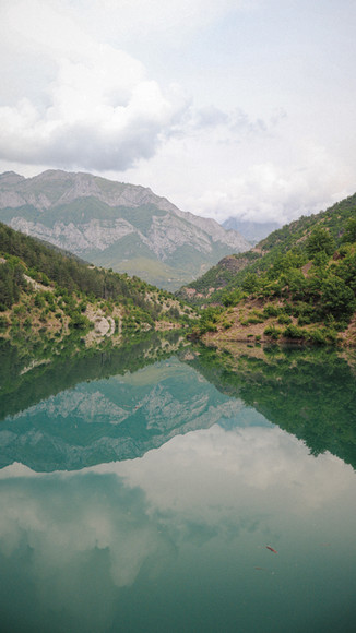
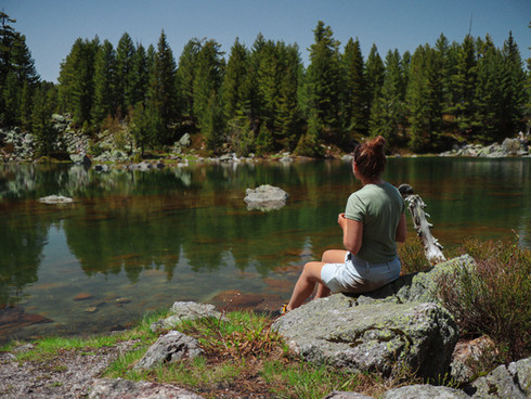
After breakfast, we packed our rucksacks and set off. Our first destination: Lake Jezero. The route to the lake involves climbing partway up the mountain on a paved road. Around noon, we arrived at the lake, which is advertised as “the most beautiful lake in Montenegro”. We therefore expected a busy lake, but there was no one there at all. It was a beautiful lake, where we found another nice spot for lunch.


After Lake Jezero, we continued our journey towards the town of Plav. This route was initially very beautiful, running along a ridge and past panoramic viewpoints (and cute lambs).


But towards the end of the day, the route became less and less enjoyable. We were no longer walking on a footpath, but on a kind of tractor track downhill for a while. Around evening time, we arrived in Plav. Plav is the largest town you encounter on the Peaks of the Balkan trail. We withdrew some money and ate in a restaurant for the first time. We also bought our lunch for the next day. Plav has several bakeries and supermarkets, so you can stock up here for the coming days. That night we slept at “Hotel & Restaurant 5E”, which was nice to have our own room again for a night and a shower.
Day 6: Grebaje Valley
Distance: 9.83 kilometres
990 metres ascent | 990 metres descent
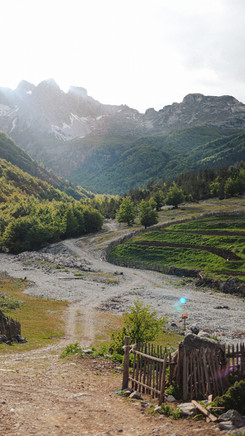
The Grebaje Valley is not officially part of the trail, but if you have an extra day, we definitely recommend it. The normal route of the Peaks of the Balkan trail goes from Plav to Vusanje, but we deviate slightly on this day to visit this beautiful national park. Over the past few days, we have kept in touch with Nedzad, the kind man who let us sleep in his house (see day 4). When we called Nedzad to ask if he could arrange a taxi for us to the Grebaje Valley, he said, “I'll come and pick you up. ” Within 10 minutes, he was at our hotel. He then took us to the valley, about 30 minutes away. It was really nice of him to take us, because most taxis drop you off at Gusinje, a village 6 km from the valley. Then we would have had to walk along the road for a while.
When we arrived at the Grebaje Valley, Nedzad told us that a relative of his had opened a new restaurant. We met Samir, the owner of the restaurant “Skala”. He also has a whole park of chalets in the valley that he rents out to tourists. The four of us drank fresh blueberry juice. Samir then said we could leave our backpacks with him for the day. That was really nice, because it was very hot that day and we had a tough walk ahead of us.
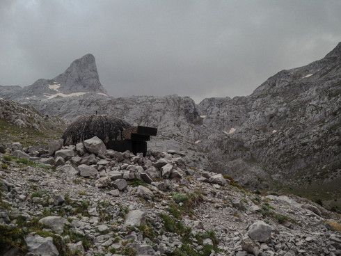
We walked the “Volusnica” route that day. First, you climb through the forest, and then through the valley. Around noon, we arrived at the viewpoint overlooking the snow-capped mountain peaks. It was truly beautiful... our favourite view during this trip.


There were more people at the first panoramic viewpoint, most of them locals from the area. It was the first time it had been a bit busier during a hike; we had hardly encountered anyone over the past few days. Most people turn back after the first viewpoint. We did the long route, which involves climbing a lot further. We found this to be the most challenging climb so far. But after climbing another few hundred metres, we reached an altitude of 2,057 metres. From there, we could see mountains all around us. A 360-degree panoramic view. It was so beautiful!


When we returned to the restaurant, Samir told us that, just after we had left, a bear with her cubs had been spotted on the mountain opposite. Bears generally keep their distance from humans, but this proves that an encounter with a bear is certainly not unrealistic.
We ate something in the restaurant and then asked Samir if he could arrange a taxi for us. “I'll take you,” he said. How kind of him! First, we drove to Gusinje, the town where Samir lives. As we drove through Gusinje, Samir showed us some enormous houses. He told us that many Americans live in the “town” of Gusinje. They have had villas built here as holiday homes and come here for about a month each year to spend their holidays. The rest of the year, these houses stand empty and nothing happens there. It's a strange sight, a town with lots of big houses, all of which are now empty.
In Gusinje, Samir parked the car in the shopping street. He fancied a coffee. We also ordered something to drink. After that, Samir took us to our accommodation in Vusanje. We spent the night in a chalet at “Eko Katun Prokletije”. We decided to stay here an extra night so that we could have a rest day the next day. After five days of walking, we were starting to feel some aches and pains, so a day of rest was welcome.
Day 7: Rest day in Vusanje
The Eko Katun Prokletije park is a wonderful place to take a rest day. The chalet has hot water for showers, a comfortable bed and laundry facilities. In the evening, we ate at the park. After dinner, we were served “Rakija”, the national drink of the Balkans. Very strong and intense. After that, we relaxed a bit and went to bed early. The next day, the longest hike of our Peaks of the Balkan trail was planned, so we left early.
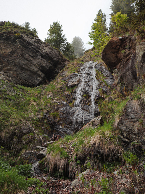
Day 8: Vusanje to Theth
Distance: 28.1 kilometres (23.8 kilometres official route)
1,280 metres ascent | 1,278 metres descent
GPX route:
This was the longest and most challenging walk of the Peaks of the Balkan trail for us. At the beginning, it certainly didn't seem that way. The first few kilometres take you through a beautiful green valley. Almost at the start of the route, you also pass a waterfall with a beautiful blue spring next to it.


In the afternoon, we began the climb to the summit. The surroundings became increasingly rugged. At the Albanian border and beyond, we saw a number of bunkers. These are located in strategic places, overlooking the valley. Albania has many bunkers anyway: as many as 24 per square kilometre.


At the top of the mountain, you will also come across an old abandoned barracks. Together with the bunkers in this area, it creates a somewhat grim atmosphere. It makes you pause for a moment to reflect on the war that was actively fought here not so long ago.


After the climb came the descent, which was long and very tiring (especially) for our knees and feet. The path zigzagged steeply downwards. The ground was rocky with loose stones, so it was difficult to walk quickly. Once we reached the village of Theth, we discovered that our guesthouse was on the other side of the river, which meant we had to walk another 45 minutes. We finally arrived at 8 p.m., after a 12.5-hour day of walking. We recommend booking a guesthouse in the centre of Theth, because that is where you will start the last stage of your hike the next day.
Day 9: Theth to Valbonë
Distance: 17.8 kilometres
991 metres of ascent | 979 metres of descent
GPX route:


Today we did the last hike from Theth to Valbonë, the place where we started hiking a week ago. This last route consists of a steep climb to the Valbonë pass. After that, you almost immediately start the descent again. The route from Theth to Valbonë is also the most famous route of the Peaks of the Balkan trail. So you see a lot of day trippers here, which makes this route a lot busier than the others.
Normally, the mountain pass does not open until mid-June because there is still too much snow. It is too dangerous to walk here until then. But according to the locals, this year (2024) is the first time in decades that the mountain pass has opened earlier. We are lucky!


We found this pass more difficult and dangerous than the other passes we had walked. Over the past few days, you could really enjoy walking on top of the mountain, but now we were more concerned with watching where we were walking. Fortunately, ropes had been attached to the rock faces in the tricky spots. And very nice: there was no snow on the route.


Towards the end of the day, we noticed that our bodies were tired after eight days of walking. The last stretch is always the hardest. We were overtaken by day tourists wearing trainers and carrying small rucksacks. They were still full of energy, while we walked the last few kilometres a little slower. But we consciously enjoyed the surroundings, because it really was the end of our wonderful adventure here in the Balkans.


Day 10: Travel day from Valbonë to Tirana via Lake Komani
At 10:30 a.m., we were picked up by the transfer to the ferry. The return journey is the same as the journey to Northern Albania: a 1-hour taxi ride, a 3-hour ferry trip and then a 3-hour taxi ride to Tirana. We also booked this trip entirely through Berisha. It is a tough day of travelling, but with the lovely weather, the ferry trip across beautiful Lake Komani felt very relaxing.
In conclusion
The Peaks of the Balkan Trail surprised us with the beauty of its unspoilt nature and the warmth of the local people. We hope that our experiences and tips will inspire you to discover this route for yourself, and we wish you just as many wonderful encounters along the way.


Comments